

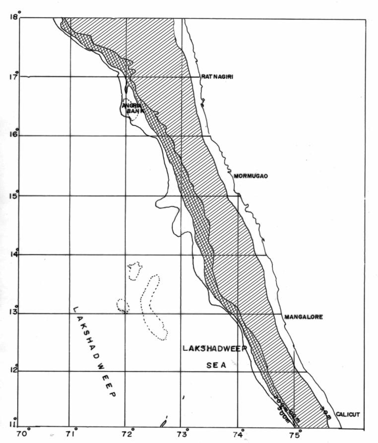
I.A.2 DEMERSAL FISHERY RESOURCES SURVEY, ASSESSMENT AND MONITORING ALONG SOUTH MAHARASTRA, GOA, KARNATAKA AND NORTH KERALA COAST BETWEEN LAT.12°N - 18°N
Project Coordinator
Shri B. Balanayak, Service Engineer (Mech.)
Project Components
- Exploratory demersal resources survey in 100-300m depth.
- Monitoring of demarsal resources in 30-100m depth
Period : April 2021 - March 2022
Project Objectives
- Preparation of species inventory of demersal fish and shell fish resources
- Estimation of abundance indices of demersal resources and major components
- Study of biological aspects of important species.
- Identifying spatio- temporal distribution pattern of the fishery resources.
- Stock assessment of important resources.
| Project Leader | Project Associates | |
|---|---|---|
| Scientist (S) | Engineer | |
|
Shri N. Unnikrishnan Jr. Fisheries Scientist |
Dr. H. D. Pradeep Fisheries Scientist Shri Raju S. Nagpure Sr. Scientific Assistant Shri Solly Solomon Sr. Scientific Assistant Shri Nashad M. Sr. Scientific Assistant |
Shri B. Balanayak, Service Engineer (Mech.) |
Base of operation : Mormugao
Vessel : MFV Sagarika
Gear
- 27m Fish Trawl
- 30m Shrimp Trawl
Vessel Officers
Skipper : Shri A. K. Mohapatra
Chief Engineer Gr.I : Vacant
Survey Strategy
- Stratified random sampling.
- The northern and southern latitudes to be surveyed in alternative months.
| Particulars | Exploratory survey | Monitoring survey | |
|---|---|---|---|
|
Gear |
FT |
ST |
FT |
|
Depth zone (m) |
100-200 |
100-300 |
30-100 |
|
Extent of Area (km) |
12265 |
18000 (Approx) |
58825 |
|
No of hauls |
12 |
18 |
20 |
Operational targets per cruise
Days out at sea : 20
Fishing days : 16
No. of hauls : 50
Duration of haul : 90 minutes
Survey area: Lat. 12°-18°N
Result reporting: As per Annexure – II
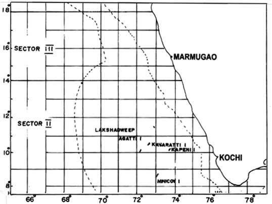
I. C.2 SURVEY OF OCEANIC TUNA AND ALLIED RESOURCES USING REGULAR LONG LINE IN THE INDIAN EEZ ALONG CENTRAL WEST COAST INCLUDING LAKSHADWEEP BETWEEN LAT 08°N - 18°N
Project Coordinator
Shri B. Balanayak, Service Engineer (Mech.)
Project Component
Survey of oceanic tuna and allied resources by longlining in the Indian EEZ along central west coast including Lakshadweep
Period: April 2021 to March 2022
Project Objectives
- Estimation of abundance index of oceanic tunas and allied resources.
- Identifying spatio-temporal distribution pattern of the above resources.
- Study of biological aspects of important species.
- Study of oceanographic parameters including tuna distribution.
- Imparting training on tuna long line fishing to the end-users.
| Project Leader | Project Associates | |
|---|---|---|
| Scientist (S) | Engineer | |
|
Dr. H. D. Pradeep Fisheries Scientist |
Shri N. Unnikrishnan Jr. Fisheries Scientist Shri Raju S. Nagpure Sr. Scientific Assistant Shri Solly Solomon Sr. Scientific Assistant Shri Nashad M. Sr. Scientific Assistant |
Shri B. Balanayak, Service Engineer (Mech.) |
Base operation : Mormugao
Vessel : MFV Yellow Fin
Gear
Multifilament Tuna Long line with 5 hooks / basket
Vessel officers
Skipper : Shri K.P. Vinoji
Chief Engineer Gr.I : Shri Joseph K. Ignacious
Survey Strategy
The vessel survey area to be divided into two sectors viz., Lat.
- 08°N-13°N and lat 13°N to 18°N. Vessel to cover each sector as
- per the distribution of sampling efforts table.
Physical targets per cruise
Days out at sea : 20
Fishing days : 14/16
Hooks per set : 625
| Sector | Area | Month | No. of sets per cruise |
|---|---|---|---|
|
I |
Lat. 08°N-13°N |
5,7,11,1,3 |
14 |
|
II |
Lat. 13°N to 18°N |
6,8,10,12,2 |
16 |
Survey area: Lat. 8° N -18°N
Collection of Environmental Data
Besides the catch data and biological data being collected in long-line survey, data on environmental parameters will be collected as follows:
- Salinity, Temperature and Depth (STD) data, per day per set.
- Sea Surface Temperature (SST) data at hourly interval from the commencement to completion of voyage.
- Data on current direction and speed, one observation every day (sets are to be made at specific depth).
- Secchi disc observation (3 readings) for every set made after setting line.
Result reporting: As per Annexure II
| Description | Apr 21 | May 21 | Jun 21 | Jul 21 | Aug 21/th> | Sep 21 | Oct 21 | Nov 21 | Dec 21 | Jan 22 | Feb 22 | Mar 22 |
|---|---|---|---|---|---|---|---|---|---|---|---|---|
|
Dry-docking & Afloat Repairs |
||||||||||||
|
Main Engine |
# |
# |
||||||||||
|
Aux. Engine(P) |
O |
# |
||||||||||
|
Aux. Engine(S) |
# |
# |
||||||||||
|
Generator(P) |
# |
|||||||||||
|
Generator(S) |
# |
|||||||||||
|
Generator(H) |
||||||||||||
|
Ref. Compr – I |
# |
# |
@ Repairs/Minor works as and when required
O- Overhauling # Inspection/Minor Repair /// SSS – Dry-docking/ Afloat Repairs, GM- General Maintenance.
|
Description |
Apr 21 |
May 21 |
Jun 21 |
Jul 21 |
Aug 21 |
Sep 21 |
Oct 21 |
Nov 21 |
Dec 21 |
Jan 22 |
Feb 22 |
Mar 22 |
|---|---|---|---|---|---|---|---|---|---|---|---|---|
|
Dry-docking & Afloat Repairs |
||||||||||||
|
Main Engine |
# |
# |
||||||||||
|
Aux. Engine(P) |
# |
# |
||||||||||
|
Aux. Engine(S) |
# |
# |
||||||||||
|
Aux. Engine(H) |
||||||||||||
|
Generator(P) |
# |
|||||||||||
|
Generator(S) |
# |
|||||||||||
|
Generator(H) |
||||||||||||
|
Ref. Compr – I |
# |
|||||||||||
|
Ref. Compr – II |
** Major Overhauling to be carried out by OEM and subject to availability of spares
O -Overhauling #- Inspection / Minor repair, ///SSS///Dry-docking/Afloat repairs, GM -General Maintenance